GOHUNT / Hunt Research & Maps
- 3.4
- Rating
- 100.00K
- Installs
- Free
- Price

 Analysis by App-foxy
GOHUNT / Hunt Research & Maps is the kind of navigation app that makes the most sense before you leave home, not after you are already standing at a trailhead with a weak signal and a long day ahead. I tested it with that mindset: first as a research tool, then as a map I would want available in the field. Its focus is hunting rather than general driving, so the useful question is not whether it can replace every map app on your phone. The better question is whether it can bring hunting research, draw information, unit details, and offline map access into one working routine.
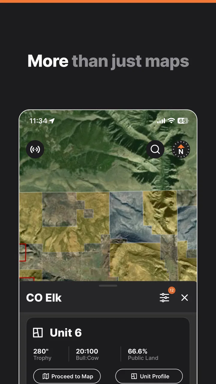
That focus is also what separates it from ordinary navigation apps. A typical map is excellent for reaching a road, business, or address. GOHUNT is aimed at helping me understand the hunting area itself and prepare around a chosen unit. The app is free to install, is rated for Everyone, and comes from goHUNT LLC. Its store presence shows more than 100K installs, a 3.4 average from around 1.3K ratings, and 268 written reviews, so it has a real user base while still leaving room for a measured opinion rather than blind enthusiasm.
Where the experience can get stuck
The first source of friction is usually expectation. Someone opening the app for a quick road route may find it too specialized, while a hunter expecting every answer to appear instantly may be surprised by how much value depends on selecting the right place, unit, season, or research context. I found that the app rewards deliberate preparation. It is less like opening a blank map and more like opening a planning workspace.
You May Also Like

 Blood Strike: 2.5 Anniversary
Blood Strike’s Loadouts Turn Every Drop Into a Tactical Gamble
A close look at Blood Strike’s custom loadouts: how fast access to signature weapons reshapes its battle royale rhythm, rewards preparation, and narrows the gap between fights.

 Pandora - Music & Podcasts
Pandora’s Music Is Easy to Start, but Harder to Recover
Pandora’s strength is its low-effort path from a seed to a station. Its weak spot is how much confidence it asks you to place in connection, setup, and quiet recovery.

 8 Ball Pool
 Is Built on Rivalries, Rematches, and Routine
A close look at the rivalries, rematches, shared routines, and unanswered safety questions that turn a quick pool match into a persistent mobile community.

 Samsung Music
’s Quiet Strength Is Playing What You Already Own
Its reach comes less from spectacle than from dependable access to a personal library. That simplicity is both the app’s strongest retention engine and its ceiling.

 AccuWeather: Weather Radar
AccuWeather Review: A Quick, Clear Forecast for Everyday Decisions
For everyday plans, the best forecast is the one you can understand quickly. AccuWeather makes rain timing, radar, and local conditions easy to act on, with a few trade-offs.

 Hill Climb Racing
Why Hill Climb Racing Still Turns Crashes Into One More Run
A tiny car, a bumpy hill and one more upgrade: Hill Climb Racing keeps resurfacing because its simple chaos makes every near-miss feel personal.
More From Our News Desk



The second issue is connectivity. Hunting areas are often exactly where mobile service becomes unreliable. An offline map is useful only when the relevant material has been prepared before the signal disappears. That sounds obvious, but it is an easy mistake to make: viewing an area while connected is not the same as proving that the information you need will remain available later. I would treat offline preparation as a separate task, not as something to assume from having browsed the map once.
A practical test is to prepare a small area at home, then switch the phone to a state where it cannot rely on normal service and inspect what remains usable. I would check the map around the access road, the likely parking area, and the sections I expect to study. This is not a dramatic technical trick; it is simply the difference between planning for a real backcountry day and trusting a screen that worked in the kitchen.
Location accuracy can also feel inconsistent even when the app is working normally. A phone may take time to settle on a position, especially indoors, under heavy cover, or in terrain that blocks a clean signal. If the marker appears to jump, I would first stop moving, give the device time, and compare the position with visible map landmarks. A single moment of uncertainty should not be treated as proof that the map itself is wrong.
Another common sticking point is information overload. Draw odds, unit profiles, research tools, and maps all answer different questions. If I begin by opening everything at once, the app can feel more complicated than it really is. I get better results by deciding what I am doing first: comparing possible units, learning one unit, or navigating within an already chosen area. That simple order prevents research screens from competing with the map when I only need one of them.
Setup checks that save time later
My preferred setup starts with a clear research question. For example, I might ask which unit deserves closer attention, what the unit profile tells me, or which map area I need ready for a trip. I then move through the app in that order instead of treating the home screen as a menu to explore randomly. This makes it easier to notice whether I have selected the correct unit and whether the map view matches the area I intended to study.
I would also sign in and complete the initial setup while connected to a dependable network. I do not like troubleshooting account or loading problems at a trailhead. If the app needs time to display research material or map content, doing that at home makes the difference between a calm preparation session and a frustrating one. The current version is 12.1.0, and the minimum operating system is Android 9, so an older phone should be checked before relying on it for a trip.
Storage planning matters even though it is easy to overlook. Offline map material takes space, and a phone already crowded with photos, videos, and other downloads may not be a good foundation for field use. I would remove unnecessary files, keep the device charged, and avoid downloading a huge region simply because it is available. A focused area is easier to manage and faster to verify than an oversized collection of maps that I will never inspect.
Before leaving, I would check three things separately: the selected hunting area, the map coverage I expect to use, and the phone’s ability to show my position. I would not assume that a successful search for a unit automatically means every map view is ready offline. I would also avoid making the app my only source of orientation. A charged phone, sensible route planning, and basic awareness of the terrain remain important even when the digital map is prepared properly.
The app is free to download, but its in-app purchases range from $74.99 to $499.99 per item. That changes how I would approach it. I would explore the free experience and understand the workflow before committing to a costly purchase. The price range suggests that serious users should think about the value of the research they need, rather than treating every additional option as an automatic upgrade. For occasional hunters, the free portion may be enough to decide whether the app fits their habits; for dedicated users, the investment deserves a more careful comparison with their existing tools.
Recovering a broken workflow
When something fails to load, I start with the simplest recovery path. I check the connection, close and reopen the app, and return to the specific unit or map area rather than repeatedly tapping the same screen. If the problem appears only in one location, I compare it with another area while connected. That helps separate a general app problem from a narrow loading or coverage issue without turning a small glitch into a full reset.
If the map seems empty or incomplete, I retrace the preparation sequence. I confirm that I am looking at the intended region, then check whether the content was actually made available for offline use. I also look at the phone’s available storage and battery condition. A failed download, an almost-full device, or an interrupted connection can all produce a result that looks like a map problem even when the underlying workflow simply did not finish.
For research screens, I would change only one thing at a time. If I alter the unit, season, or search context and several results change at once, it becomes difficult to know what caused the confusion. Returning to a known unit and rebuilding the search gives me a cleaner baseline. This is particularly useful when comparing draw odds or unit profiles, because a small selection mistake can make a correct result seem irrelevant.
Offline recovery is more limited by nature. Once I am out of service, I cannot expect a fresh download or a missing page to appear. That is why I consider an offline test part of setup, not emergency troubleshooting. I would open the saved map before leaving coverage, zoom into the areas that matter, and make sure the phone behaves as expected. If it fails at home, I can fix the preparation; if it fails in the field, my options are much narrower.
It is also worth keeping the phone’s basic environment stable. Extreme battery-saving behavior, a nearly full storage area, or a device that is already struggling with several demanding apps can make navigation feel unreliable. I would close unrelated apps, carry a power bank, and avoid using the screen brightness at maximum for the entire day. Those steps do not change GOHUNT itself, but they improve the conditions in which I am asking it to work.
When the app is not the cause
Not every inaccurate-looking position comes from the application. Dense trees, steep terrain, poor satellite visibility, and a phone that has not established a stable location can all affect the marker. If I am standing near a boundary or a narrow access route, a small position error can feel more serious than it is. I use the map as one source of orientation and compare it with the landscape, known roads, and my planned route rather than treating one pixel on a screen as absolute truth.
Map information also needs sensible interpretation. A unit profile or research result can help me prepare, but it does not replace checking current local rules, access conditions, closures, or safety requirements. Those details can change outside the app’s control. I would use GOHUNT to organize my questions and narrow my research, then verify time-sensitive decisions through the appropriate official sources before acting on them.
There is a similar distinction between a draw-odds tool and a guarantee. Draw information can support a strategy, but it cannot promise an outcome. I would use it to compare possibilities and understand how aggressive a choice might be, not to treat a favorable-looking result as certainty. This is one of the app’s most useful planning roles when handled carefully, and one of its easiest features to misuse when numbers are read without context.
For navigation, I would not choose this app as my only tool if my main need is turn-by-turn driving directions, transit planning, or broad city search. General map services are usually more convenient for those jobs. GOHUNT becomes the better fit when the trip involves hunting-unit research and map preparation, especially when I want those tasks connected rather than scattered across several unrelated apps.
It is also not the ideal choice for someone who wants a completely effortless experience. The app asks me to prepare, select the right area, understand what I am viewing, and test offline access. That is a fair trade for a hunting-focused tool, but it is still a trade. A casual user who hunts rarely and only needs a road map may find a standard navigation app simpler and less expensive.
A realistic day-before-the-trip routine
Imagine I am preparing for a weekend hunt. I begin with the research side while connected, using the unit information and draw-odds tools to compare the areas already on my shortlist. I do not try to decide everything from one screen. Instead, I note which unit deserves a closer look, open its profile, and then move to the map to understand how the area relates to the roads and terrain I expect to encounter.
Next, I prepare the map for the specific area rather than the entire state or region. I include the approach route, likely access points, and the terrain surrounding the places I intend to study. I then inspect that material with connectivity removed. If I cannot reproduce the view I need, I fix it before packing. This workflow is more reliable than downloading something at the last minute and assuming it succeeded.
On the morning of the trip, I use the app as a reference rather than staring at it continuously. I check my position when I need confirmation, then put the phone away and pay attention to the surroundings. This reduces battery use and keeps the map in its proper role: a planning and orientation aid, not a substitute for judgment. If the route changes, I can reassess from the saved material instead of depending on a live connection.
Afterward, the same organization can help with future planning. I can revisit the unit research, compare what I expected with what I encountered, and decide whether the area deserves another look. The useful insight here is that GOHUNT is not only a field map. Its strongest value may come from combining preparation and navigation so that the map reflects a decision I have already thought through.
Who will get the most from it
I would recommend it most strongly to hunters who make decisions around units, draw research, and offline map preparation. It is particularly appealing if you dislike switching between a general map, separate research pages, and notes scattered across your phone. Bringing those activities into one hunting-oriented app can make the planning process easier to repeat and easier to audit before a trip.
It can also suit a careful beginner who is willing to learn the workflow. The Everyone content rating makes it broadly accessible, but accessibility does not mean every feature is self-explanatory on the first visit. I would encourage a new user to start with one unit and one planned outing, rather than trying to master the entire catalog immediately. That smaller test reveals whether the map style and research tools match the way the person actually hunts.
I would be more cautious recommending it to someone who rarely hunts, needs only ordinary road directions, or is unwilling to prepare offline content in advance. I would also pause before paying for the higher-priced in-app options until the free experience has demonstrated a clear benefit. The app can be valuable, but the value depends heavily on how often its specialized research and mapping tools will be used.
My final impression is positive but practical. GOHUNT / Hunt Research & Maps is not a universal navigation replacement, and it is not a magic answer to weak service, uncertain location signals, or changing field conditions. Its strength is more specific: it gives hunting-focused users a place to research units, consider draw odds, study profiles, and prepare maps for offline use. The best results come from treating preparation as part of navigation.
With that expectation, I can see why the app has attracted more than 100K installs despite its middling 3.4 average. It offers a focused workflow that ordinary map apps do not aim to provide. At the same time, the purchase range and setup demands mean I would not recommend it automatically to every hunter. I would install it, test one complete research-to-offline-map routine, and judge it by whether that routine genuinely reduces the work before my next trip.
GOHUNT LLC has built an app for a defined audience, and that is its biggest advantage. For me, it works best as a planning partner that remains useful when service disappears, provided I have done the preparation properly. If that matches the way you hunt, it is worth exploring. If you only need directions or a quick glance at a general map, a simpler alternative will probably serve you better.
FAQs for GOHUNT / Hunt Research & Maps
01What is GOHUNT / Hunt Research & Maps used for?
GOHUNT is a hunting-planning app designed to help hunters research public-land opportunities, study hunting units, review regulations, and prepare for upcoming seasons. Its mapping tools can display boundaries, terrain, access information, and other useful layers, while research features help compare units and organize decisions before heading into the field. Availability and depth of information can vary by state and species.
02Does GOHUNT provide offline maps for areas without cell service?
Yes, GOHUNT is built with backcountry use in mind and supports downloading maps for offline access, depending on the feature and subscription plan available in your region. Before leaving home, users should download the required map areas and confirm that they work with the phone in airplane mode. Offline maps do not replace preparation, a compass, or knowledge of local terrain.
03Is GOHUNT free to download, and do I need a subscription?
The app can generally be downloaded at no initial cost, but many of its most valuable tools may require a paid membership or subscription. Premium access can include advanced map layers, detailed unit research, draw and application information, offline functionality, and additional planning resources. Pricing, trial offers, and included features may differ by platform, location, and current GOHUNT membership terms.
04Which hunting areas, states, and species does GOHUNT support?
GOHUNT focuses primarily on hunting research in the United States, with coverage for selected states, game species, seasons, units, and application systems. The exact information available depends on where you hunt and what species you pursue. Since regulations and boundaries can change, hunters should check the app’s current coverage and always confirm details with the relevant state wildlife agency before hunting.
05Can GOHUNT replace official regulations and navigation equipment?
No. GOHUNT is a useful research and mapping aid, but it should not be treated as the sole authority for legal requirements or as a complete substitute for reliable navigation equipment. Regulations, access rules, season dates, tags, and boundary information can change or contain updates. Always verify critical details through official wildlife agencies, carry backup navigation tools, and prepare for limited battery or signal.
Pros
- Detailed hunting maps with public and private land boundaries.
- Strong unit research tools for tags
- seasons
- and draw odds.
- Offline map access is useful in remote areas without cell service.
- Waypoint and route features help organize scouting information.
- Regularly updated data supports planning across multiple western states.
Cons
- Many advanced features require a relatively expensive paid membership.
- Coverage and data quality can vary between states and hunting units.
- The large amount of information may feel overwhelming for new hunters.
- Offline maps require advance downloads and can use substantial storage.
- Some features depend on GPS accuracy and may drain the phone battery.

GOHUNT / Hunt Research & Maps
Gallery